Skip to content

FEATURED CASE STUDY • STRATEGIC CONCEPT

Designing a digital territorial system for clearer locations, stronger local intelligence, and better public decisions.

A location may be familiar to residents while remaining difficult to describe consistently across institutions, public services, delivery operations, development programs, and digital systems.

When territorial information is fragmented across informal directions, institutional files, community knowledge, and disconnected maps, coordination becomes more difficult.

DATIS explores how digital addressing, local knowledge, territorial data, public assets, routes, services, and institutional responsibilities could be organized within one responsible territorial-information architecture.

Concept-stage noteDATIS remains a Strategic Concept. It has not been deployed, institutionally adopted, or connected to official public registries.

Category
Territorial Intelligence & Digital Public Infrastructure
Maturity
Strategic Concept
Geographic frame
Haiti

Discuss a Territorial Challenge

Abstract representation of the DATIS territorial-information concept. Illustrative only.

Project Snapshot

Project snapshot

Project
DATIS
Full name
Digital Addressing & Territorial Information System
Maturity
Strategic Concept
Geographic frame
Haiti
Period
2026–Present
Project area
Digital Addressing, Territorial Intelligence & Digital Public Infrastructure

Concept purpose

Explore how communities and institutions could reference locations, routes, services, infrastructure, and territorial information through one coordinated digital system.

Potential primary users

Potential user groups, not confirmed institutional partners.

  • Local governments
  • Community organizations
  • Public-service teams
  • Development institutions
  • Infrastructure and utility actors
  • Emergency-preparedness teams
  • Logistics and delivery operations
  • Researchers and territorial planners

Contribution

  • Territorial problem framing
  • Strategic concept development
  • Stakeholder mapping
  • User and use-case architecture
  • System-layer design
  • Data-relationship logic
  • Governance principles
  • Phased implementation strategy
  • Human-centered digital direction

THE TERRITORIAL CONTEXT

A place can be well known locally and still remain difficult to reference institutionally.

Communities often understand their territories through lived experience, landmarks, local names, routes, social relationships, and shared memory.

Institutions and digital systems require information that can be described, updated, compared, and communicated consistently.

The challenge is not to replace community knowledge. It is to connect local understanding with practical territorial references that can support coordination without erasing cultural, geographic, or social context.

  • 01

    Informal location references

    Directions may depend on landmarks, family names, local expressions, or knowledge held by residents.

  • 02

    Fragmented territorial information

    Different institutions may maintain separate records, maps, lists, or operational references.

  • 03

    Unequal digital visibility

    Some roads, neighborhoods, services, public assets, and community spaces may be poorly represented in digital tools.

  • 04

    Operational consequences

    Location uncertainty may affect delivery, infrastructure maintenance, field operations, public services, and development planning.

  • 05

    Community knowledge

    Residents possess essential territorial knowledge that formal systems may not capture accurately.

THE CHALLENGE

How can a territorial system create shared reference without flattening local reality?

A digital addressing system cannot be reduced to assigning numbers to buildings.

It must connect administrative geography, community naming, routes, landmarks, services, public assets, access conditions, verification, maintenance, and institutional responsibility.

The concept must also remain usable for people who understand the same place in different ways.

  • Location consistency

    Create a reference that can be understood across community, institutional, operational, and digital contexts.

  • Local knowledge integration

    Preserve landmarks, locality names, access patterns, and community understanding within the territorial record.

  • Data relationships

    Connect addresses to territories, routes, services, infrastructure, institutions, and relevant metadata.

  • Institutional coordination

    Clarify which actors create, validate, update, use, and govern different territorial-information layers.

  • Usability and access

    Design a system that can support field users, administrators, communities, and decision-makers with different technical capacities.

  • Trust and responsibility

    Protect privacy, avoid unsupported legal claims, document data sources, and maintain transparent verification status.

THE STRATEGIC CONCEPT

One territorial-information architecture connecting places, people, infrastructure, services, and institutions.

DATIS is structured as a layered territorial concept rather than a single map.

Each layer contributes a different part of the shared understanding required to reference locations, coordinate services, plan interventions, and support local decisions.

  1. LAYER 1

    Digital Addressing

    Under Development

    Develop consistent location references connecting administrative context, locality, route, landmark, address point, and verification status.

    Concept components

    • Administrative hierarchy
    • Locality and neighborhood reference
    • Road, path, or access route
    • Landmark context
    • Address point
    • Optional geographic coordinates
    • Verification status
    • Update history
  2. LAYER 2

    Territorial Reference

    Concept Defined

    Organize the geographic and community relationships that explain where a location belongs and how it is accessed.

    Concept components

    • Department
    • Commune
    • Communal section
    • Habitation or locality
    • Neighborhood
    • Route relationship
    • Access conditions
    • Community reference names
  3. LAYER 3

    Public Assets & Infrastructure

    Concept Defined

    Create a structured reference for public facilities, roads, bridges, water systems, markets, schools, health facilities, and other territorial assets.

    Concept components

    • Asset category
    • Location reference
    • Responsible institution
    • Operational purpose
    • Condition or status field
    • Service relationship
    • Update responsibility
  4. LAYER 4

    Services & Community Access

    Concept Defined

    Connect territorial locations to the public, community, institutional, and operational services available within or near them.

    Concept components

    • Service point
    • Service category
    • Coverage area
    • Access route
    • Operating context
    • Responsible organization
    • Public information status
  5. LAYER 5

    Field Data & Operational Intelligence

    Future Pilot Requirement

    Support responsible field observation, verification, update requests, infrastructure reports, and territorial information collection.

    Concept components

    • Field record
    • Observation type
    • Source
    • Date
    • Verification status
    • Responsible reviewer
    • Update decision
    • Audit history
  6. LAYER 6

    Governance & Interoperability

    Under Development

    Define how territorial information could be created, validated, shared, protected, updated, and connected across institutions.

    Concept components

    • Data stewardship
    • Institutional roles
    • Community-validation process
    • Access permissions
    • Interoperability principles
    • Publication controls
    • Privacy protections
    • Maintenance model

DULAIN’S CONTRIBUTION

Territorial experience translated into system architecture and implementation logic.

DATIS developed from a combination of communication, community engagement, local-governance experience, territorial observation, development practice, field implementation, and digital-product thinking.

The contribution focuses on translating a complex territorial challenge into a structured, understandable, and responsibly phased concept.

  • Problem Framing

    Defined the relationship between informal addressing, territorial knowledge, institutional coordination, public services, logistics, and digital visibility.

  • Stakeholder Architecture

    Mapped the potential roles of communities, municipalities, public institutions, service providers, development actors, and operational users.

  • System Design

    Structured DATIS as interconnected addressing, territorial, infrastructure, service, field-data, and governance layers.

  • Data-Relationship Logic

    Defined how location references could connect to routes, landmarks, assets, institutions, services, users, and verification records.

  • Human-Centered Product Direction

    Positioned the system around practical user needs, local knowledge, field realities, accessibility, and responsible technology.

  • Implementation Strategy

    Developed a phased approach moving from discovery and local validation toward pilot testing, institutional learning, and possible future scaling.

STAKEHOLDER ECOSYSTEM

Territorial information becomes useful when responsibilities and perspectives are connected.

  • Communities & Residents

    Potential role

    • Share locality knowledge
    • Identify landmarks
    • Validate access routes
    • Report changes
    • Review public-facing references
  • Local Governments

    Potential role

    • Coordinate territorial records
    • Support local validation
    • Reference public assets
    • Use information for planning
    • Define update responsibilities
  • Public-Service Teams

    Potential role

    • Reference service locations
    • Understand access conditions
    • Support operational coordination
    • Report infrastructure or territorial changes
  • Development Organizations

    Potential role

    • Support territorial analysis
    • Plan field interventions
    • Coordinate community and institutional data
    • Evaluate geographic access conditions
  • Infrastructure, Utility & Logistics Actors

    Potential role

    • Reference routes and service points
    • Understand access constraints
    • Plan operations
    • Update infrastructure-related information
  • National Institutions & Standards Bodies

    Potential role

    • Consider interoperability
    • Align administrative references
    • Define standards
    • Support responsible scaling

DIGITAL ADDRESSING

An address should explain both where a place is and how it is understood.

A DATIS address concept would need to connect formal territorial structure with practical local reference.

A useful record may include several complementary elements rather than relying on one code or coordinate alone.

  1. L1

    Administrative context

    • Department
    • Commune
    • Communal section
  2. L2

    Local territorial context

    • Habitation
    • Locality
    • Neighborhood
    • Community-recognized name
  3. L3

    Access context

    • Road
    • Path
    • Route
    • Entry point
    • Access condition
  4. L4

    Landmark context

    • Nearby public facility
    • Recognized landmark
    • Intersection
    • Community reference
  5. L5

    Address point

    • Building or destination reference
    • Address-point identifier
    • Optional coordinates
    • Verification status
    • Last update date

The final address model would require field research, community validation, institutional review, technical testing, and alignment with applicable public standards.

DATA RELATIONSHIPS

The value of territorial information comes from the relationships between the records.

Conceptual entities

  • Territory
  • Administrative unit
  • Locality
  • Route
  • Landmark
  • Address point
  • Public asset
  • Service point
  • Institution
  • Field observation
  • Verification record
  • Update request

Relationship principles

  1. 01Every address belongs to a territorial context.
  2. 02Every location may connect to one or more routes and landmarks.
  3. 03Public assets and service points require location and institutional context.
  4. 04Field observations must retain source, date, and verification status.
  5. 05Updates must preserve responsibility and history.

POTENTIAL APPLICATIONS

One territorial foundation could support several forms of public and operational work.

  • Local planning

    Help local authorities and community actors understand where services, infrastructure, needs, and access conditions intersect.

  • Public-service coordination

    Provide clearer territorial references for teams planning or delivering public and community services.

  • Emergency preparedness

    Support future planning around routes, landmarks, facilities, access conditions, and territorial reference. Live emergency-response capability is not claimed.

  • Infrastructure management

    Organize location and responsibility information for roads, bridges, water systems, public facilities, and other territorial assets.

  • Logistics & delivery

    Improve future location reference for delivery, supply movement, field operations, and service access.

  • Development programs & research

    Support territorial analysis, field planning, community engagement, monitoring design, and evidence-informed intervention.

COMMUNITY-GROUNDED DESIGN

Territorial intelligence should not erase the people who already understand the territory.

Digital systems can create a false impression that information becomes accurate simply because it appears on a map.

DATIS proposes that local knowledge, institutional records, field verification, and technical information must be brought into a transparent validation process.

  • Local names matter

    Community-recognized names and landmarks provide practical territorial meaning.

  • Residents are knowledge holders

    Community members should not be treated only as data subjects.

  • Verification should be visible

    Users should understand whether a record is proposed, community-validated, institutionally reviewed, or outdated.

  • Disagreement should be documented

    Different names or territorial interpretations may require review rather than silent replacement.

  • Updates require responsibility

    Every change should identify its source, review status, and decision pathway.

  • Participation should remain accessible

    Field and community engagement must consider language, literacy, connectivity, mobility, and technical access.

RESPONSIBLE DIGITAL INFRASTRUCTURE

A territorial system must define not only what it knows, but who is responsible for that knowledge.

  • 01

    Purpose limitation

    Collect territorial information for defined public, community, planning, or operational purposes.

  • 02

    Minimum necessary personal data

    Do not collect resident information when territorial or location data is sufficient.

  • 03

    Clear data stewardship

    Define which institution or authorized body is responsible for each information layer.

  • 04

    Community participation

    Create appropriate processes for local validation, correction, and feedback.

  • 05

    Verification status

    Distinguish proposed, observed, validated, reviewed, published, and outdated records.

  • 06

    Access control

    Separate public territorial information from restricted operational or personally sensitive information.

  • 07

    Interoperability without uncontrolled exposure

    Support appropriate data exchange while protecting restricted information.

  • 08

    Maintenance and audit history

    Preserve sources, dates, changes, responsibilities, and review decisions.

FROM TERRITORIAL CHALLENGE TO PILOT-READY CONCEPT

A responsible territorial system must be developed through research, validation, testing, and institutional learning.

  1. 01

    Listen to the territory

    Understand how residents, institutions, and operational teams currently describe and navigate places.

  2. 02

    Map the stakeholder system

    Clarify users, responsibilities, information sources, institutional relationships, and decision needs.

  3. 03

    Define the data model

    Structure territories, routes, landmarks, address points, assets, services, institutions, observations, and verification records.

  4. 04

    Design the addressing logic

    Develop and test location-reference structures without prematurely imposing an unsupported standard.

  5. 05

    Select a pilot territory

    Future Pilot Requirement

    Identify a manageable geography, institutional context, and practical use case for future testing.

  6. 06

    Conduct field and community validation

    Future Pilot Requirement

    Compare conceptual records with local knowledge, physical access, institutional information, and observed territorial reality.

  7. 07

    Test workflows and governance

    Future Pilot Requirement

    Evaluate data entry, validation, correction, institutional roles, access control, and system usability.

  8. 08

    Review before scaling

    Future Pilot Requirement

    Assess evidence, costs, governance, maintenance, standards, and institutional readiness before expansion.

METHOD IN PRACTICE

DATIS illustrates how territorial complexity can be translated into shared understanding and system architecture.

DATIS illustrates several dimensions of The Dulain Method™ at the strategic-concept stage.

  • LISTEN

    Understand how communities, institutions, and operational actors currently identify and navigate territorial locations.

  • UNDERSTAND

    Clarify administrative structures, local knowledge, routes, services, assets, institutional responsibilities, and access conditions.

  • ANALYZE

    Identify data gaps, conflicting references, stakeholder relationships, governance needs, and technical constraints.

  • ALIGN

    Connect community knowledge, institutional priorities, standards, user needs, privacy, and implementation responsibilities.

  • DESIGN

    Structure the addressing logic, territorial-data model, system layers, governance principles, interfaces, and pilot pathway.

  • IMPLEMENT

    At the current stage, implementation refers to concept documentation, system architecture, and preparation for future validation—not operational deployment.

  • STRENGTHEN

    Develop reusable data, governance, stakeholder, and implementation frameworks.

  • SUSTAIN

    Plan for responsible maintenance, institutional ownership, community correction, interoperability, and long-term territorial learning.

CURRENT STATE

A developed strategic concept with critical validation and implementation stages still ahead.

Concept defined
  • Project purpose
  • Territorial problem framing
  • Digital-addressing direction
  • Six-layer system architecture
  • Potential stakeholder ecosystem
  • Potential use cases
  • Community-participation principles
  • Responsible-data principles
  • Phased concept-development pathway
  • Evidence architecture
Under development
  • Detailed conceptual data model
  • Addressing-reference structure
  • Governance framework
  • Institutional-role matrix
  • User journeys
  • Interface direction
  • Pilot-selection criteria
  • Sustainability and maintenance model
Future pilot requirements
  • Institutional engagement
  • Community consultation
  • Pilot-territory selection
  • Field research
  • Data collection and verification
  • Prototype development
  • Technical testing
  • Governance validation
  • Public-standard alignment
  • Evidence-based pilot evaluation

DATIS remains a Strategic Concept. It is not operational, piloted, deployed, government-approved, institutionally adopted, nationally standardized, collecting resident data, managing public infrastructure, or supporting live emergency operations.

CONCEPT EVIDENCE

System thinking made visible through governed concept artifacts.

These artifacts document DATIS’s proposed architecture, validation pathways, stakeholder logic, field-data workflow, and governance requirements. They do not represent a deployed, piloted, adopted, or government-approved system.

Conceptual system artifact — DATIS is a Strategic Concept; no deployment, institutional adoption, pilot, or verified results are claimed.

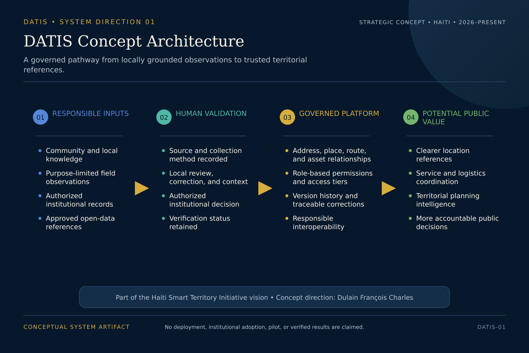
DATIS Concept Architecture

DATIS concept architecture showing four stages: responsible inputs, human validation, governed platform, and potential public value.
Conceptual architecture connecting responsible data inputs, human validation, a governed territorial platform, and potential public value within the DATIS vision.

Conceptual system artifact — DATIS is a Strategic Concept; no deployment, institutional adoption, pilot, or verified results are claimed.

View full-size diagram

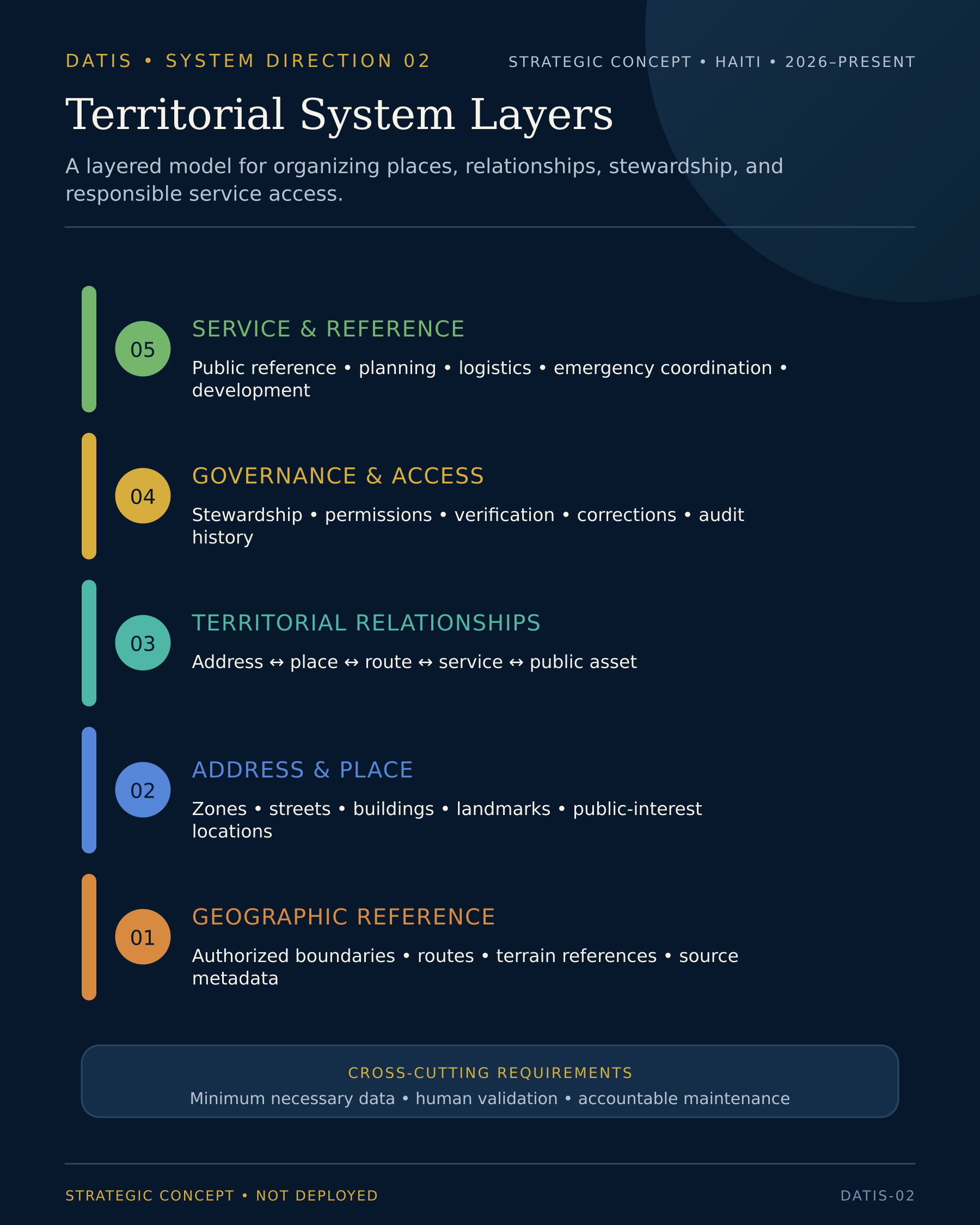
Territorial System-Layer Diagram

Five-layer DATIS diagram showing geographic reference, address and place, territorial relationships, governance and access, and service and reference layers.
Layered territorial-information model organizing geographic reference, addresses and places, territorial relationships, governance and access, and potential service applications.

Conceptual system artifact — DATIS is a Strategic Concept; no deployment, institutional adoption, pilot, or verified results are claimed.

View full-size diagram

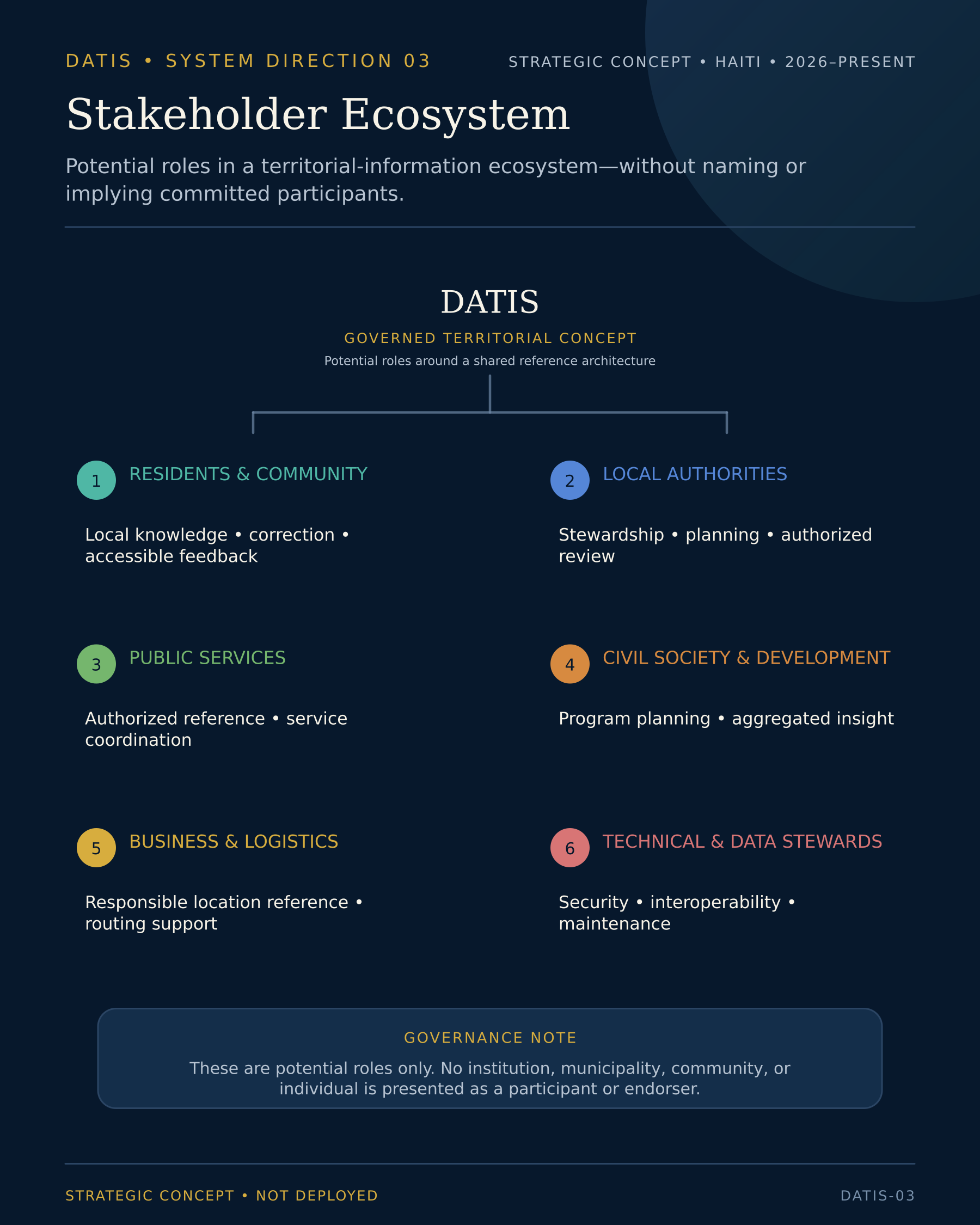
Stakeholder Ecosystem Map

DATIS stakeholder map showing six potential groups around a governed territorial concept, without naming participating institutions.
Potential stakeholder ecosystem illustrating how communities, local authorities, public services, civil society, businesses, logistics providers, and technical stewards could relate to the DATIS concept.

Conceptual system artifact — DATIS is a Strategic Concept; no deployment, institutional adoption, pilot, or verified results are claimed.

View full-size diagram

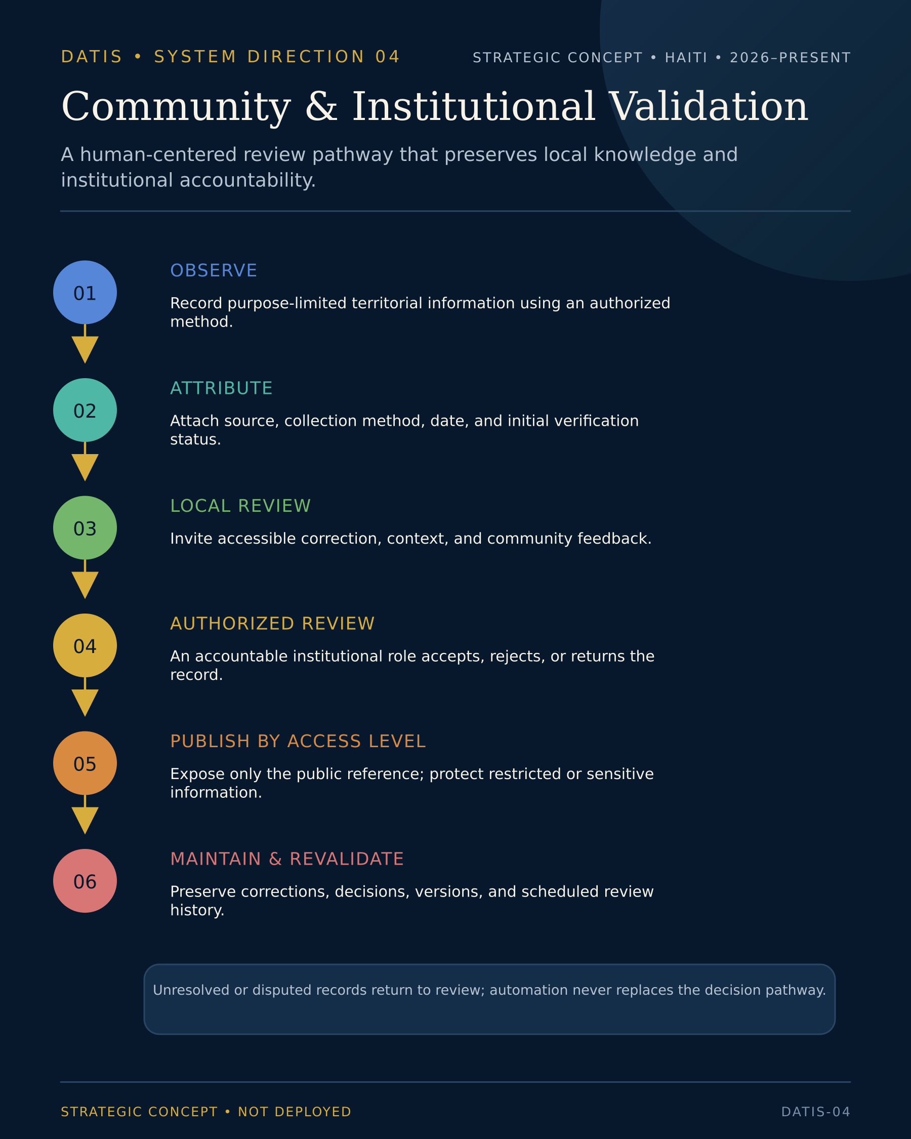
Community & Institutional Validation Workflow

Six-step DATIS validation workflow from observation and source attribution through community and institutional review, controlled publication, and maintenance.
Human-centered validation pathway covering observation, source attribution, community review, authorized review, access-level publication, and continued revalidation.

Conceptual system artifact — DATIS is a Strategic Concept; no deployment, institutional adoption, pilot, or verified results are claimed.

View full-size diagram

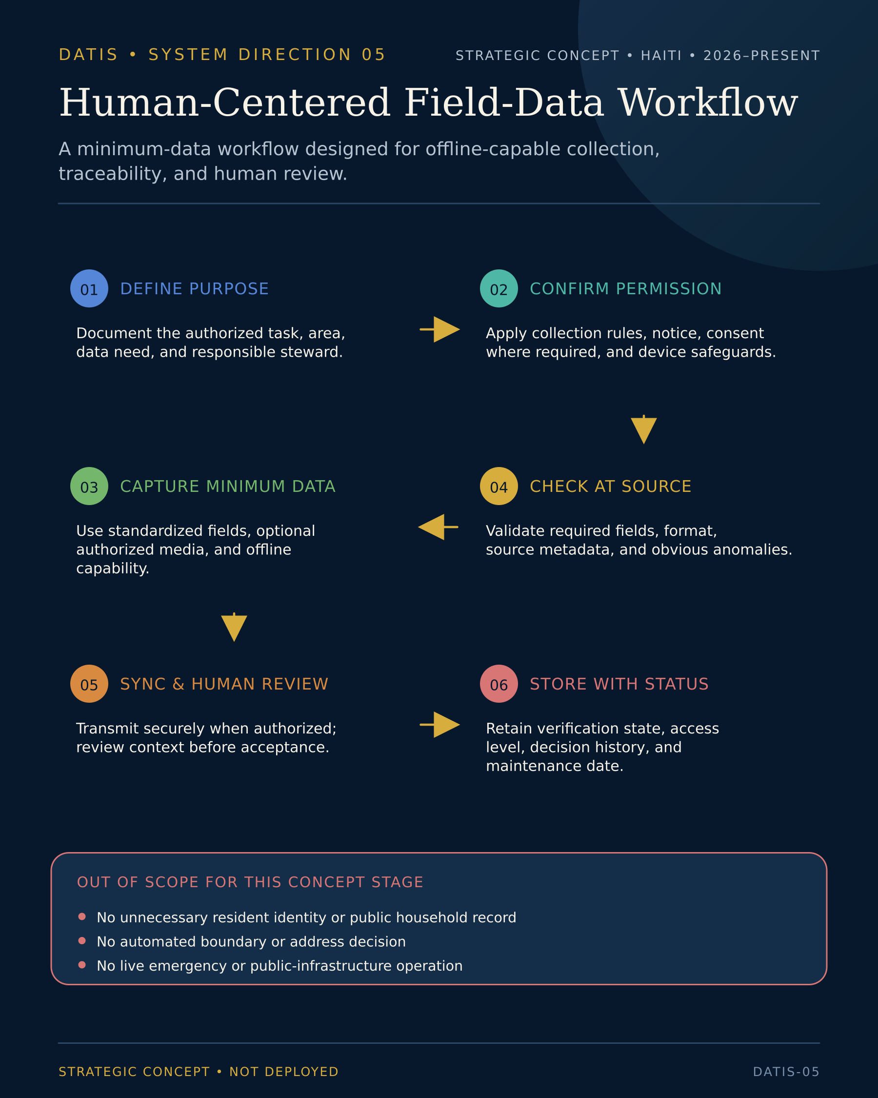
Human-Centered Field-Data Workflow

Six-step DATIS field-data workflow showing purpose, permission, minimum-data capture, source checks, human review, and governed storage.
Minimum-data field workflow designed for purpose definition, permission, offline-capable capture, source checks, human review, and status-controlled storage.

Conceptual system artifact — DATIS is a Strategic Concept; no deployment, institutional adoption, pilot, or verified results are claimed.

View full-size diagram

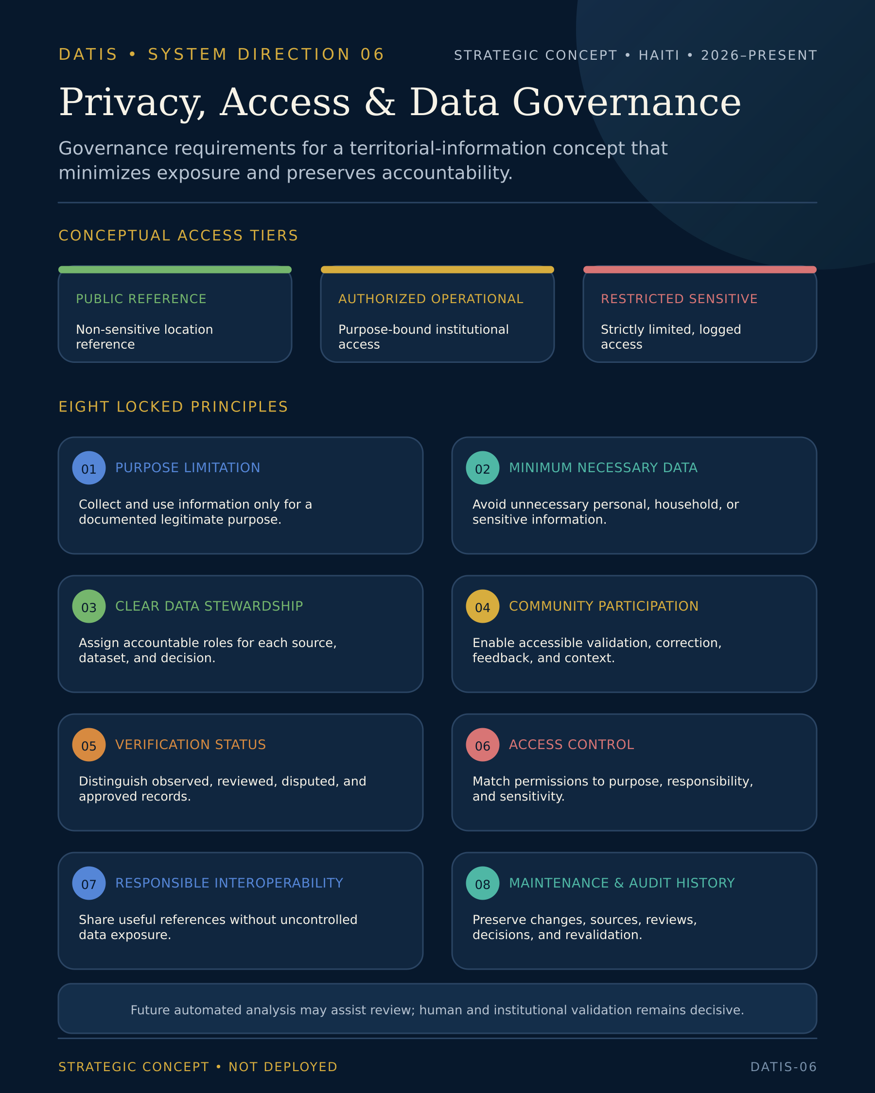
Privacy, Access & Data-Governance Framework

DATIS privacy framework showing three access tiers and eight governance principles, with human and institutional validation remaining decisive.
Privacy and data-governance framework defining conceptual access tiers and eight principles for stewardship, verification, controlled access, interoperability, and auditability.

Conceptual system artifact — DATIS is a Strategic Concept; no deployment, institutional adoption, pilot, or verified results are claimed.

View full-size diagram

PROFESSIONAL VALUE

A territorial challenge becomes actionable when people, data, institutions, and implementation logic are designed together.

  • Territorial Systems Thinking

    Framing places, routes, services, assets, institutions, and responsibilities as one connected concept.

  • Strategic Concept Development

    Translating a complex territorial challenge into a phased, evidence-conscious architecture.

  • Stakeholder Architecture

    Mapping communities, institutions, and operational actors around clearly defined roles and information layers.

  • Digital Public Infrastructure

    Structuring territorial information as a shared, responsible foundation rather than a single product.

  • Human-Centered Product Strategy

    Grounding the system in field realities, local knowledge, and accessible user needs.

  • Data & Governance Design

    Defining stewardship, verification, privacy, and maintenance conditions for territorial records.

LESSONS

Territorial intelligence begins with shared reference—not technology alone.

  • A location is more than a coordinate

    Administrative context, routes, landmarks, local names, access conditions, and community understanding all contribute to a useful location reference.

  • Community knowledge is infrastructure

    Residents hold territorial information that formal systems may not capture without deliberate participation and validation.

  • Data requires responsibility

    A territorial record becomes trustworthy when its source, status, reviewer, update history, and institutional responsibility remain visible.

  • A map is not the system

    The deeper system includes users, governance, workflows, services, assets, maintenance, standards, and institutional coordination.

  • A strategic concept must protect the difference between vision and deployment

    Clear maturity language prevents a proposed system from being misrepresented as an operational or institutionally adopted platform.

Related Professional Pathways

Expertise

Explore the strategy, systems, data, stakeholder, and digital-infrastructure capabilities behind the concept.

Explore My Expertise

Method

Understand the methodology connecting territorial listening, analysis, alignment, design, validation, and sustainability.

Explore The Dulain Method™

Contact

Discuss a territorial, institutional, digital-infrastructure, or public-system challenge.

Start a Conversation

FROM TERRITORIAL COMPLEXITY TO SHARED REFERENCE

Does your territory, institution, or public initiative need clearer location intelligence and a more connected information system?

Let’s examine the communities, users, administrative structures, routes, assets, services, data relationships, governance requirements, and implementation conditions—and develop a responsible territorial-system concept grounded in real context.

Back to All Work